Roman Road to Winchester - Roe Downs Farm
MAGNETOMETARY ON SOUTHERN PARALLEL FEATURE
Magnetometary was conducted
on northern parallel feature in
Ref 1,
and is here repeated on
the southern feature. We have had problems with OS Map error, which has been
corrected by constructing the
Air
Photo Map
of the features around Roe Downs Farm and Chawton Park Wood (Ref
2). This southern feature has air photo characteristics of a Roman Road, with
two dark lines with a light line between. A terrace runs on the line through
Chawton Park Wood. With an accurate Air Photo Map upon which these lines appear,
we are in a position to explore the line. This magnetometary was to see if it
could pick up the ditches under the dark lines in the field west of Roe Downs
House which is visible on the Air Photo Map westward across the fields from
Chawton Park Wood.
The method was the same as in Ref 1, where max and min swings in the
magnetometer signal were compared for 5 Blocks of land: the 2 ditches D-N and
D-S, and outside the ditches and inside them. This was first done in the field
by the excavation on the western edge of Chawton Park Wood, using the Trenches
in which we expected to find these entities. Then it was repeated in the field
to the west of Roe Downs House, using measurements from the Air Photo Map.
Fig 1 shows that the dark air photo lines show up very well by the
excavation, and are likely to be ditches as they contain more soil which is more
magnetic. Block B is where a road would be between the ditches, and is slightly
less magnetic than outside the ditches - but the difference is small.
Fig 2 shows that the dark lines show up well by Roe Downs House, while Block
B is lower than the ground outside the ditches. Stone work of a road may give
this effect.
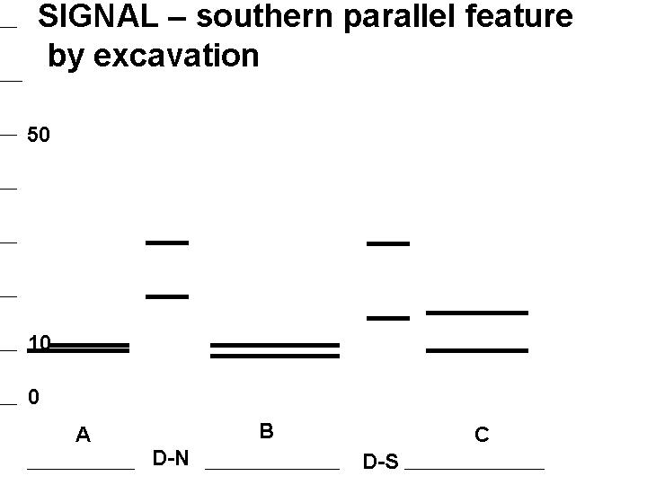
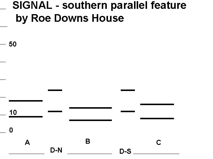
Fig 1 Traverse in field by 2012-3 excavation in Chawton Park Wood,
15m from the wire fence. The vertical scale is the Signal needle reading; whose
swings falls within the bold lines for each Block. The North Ditch D-N is taken
at Trench 2B which is 4m long, and the Southern Ditch centre D-S is taken as 50'
from Trench 2B. Threshold set at 10 (signals below this are reduced magnetic
field). Ground Balance was 4, Discriminator set at 4 giving a signal around 20
on the Ground Surface.
Fig 2 Traverse 15m from Roe Downs Road fence. The position of D-N
from Air Photo Map taken as 210' from line of southern field boundary measured
along Roe Downs Road boundary. D-S is 60' from D-N measured along Roe Downs
Road. Ground Balance was 4.2, Discriminator set at 4 giving around 20 signal
reading on Ground Surface.
Richard Whaley
REFERENCES
1. FAB e News 6, Winter 2013, http://www.nehhas.org.uk/rd12mag.htm
2.
Richard Whaley, Air Photo Map, FAB e News 4, Spring 2012 http://www.nehhas.org.uk/rd11-12.htm